Geographic Information System (GIS)
Summary
A system for visualizing and analyzing geographic information.Overview
A Geographic Information System (GIS) is any system that allows a user to input geographic information to visualize and analyze it. Geographic information includes latitude and longitude coordinates, postal addresses (country, state, city; zipcodes). GIS software allows the data to be visualized on a map.
Here's an example of data being analyzed in ArcGIS:
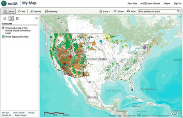
(Credit: https://www.flickr.com/photos/alper/5345887644)
Here's an example of data being analyzed in ArcGIS:
(Credit: https://www.flickr.com/photos/alper/5345887644)